The Centre for Recreation and Tourism Research (CRTR), based at West Highland College UHI, has collaborated with West Coast Waters and other stakeholders to produce a new digital marine tourism map for the west coast of Scotland.
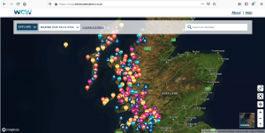
Launched in early March 2021, ‘MaraMap’ is an interactive map that allows visitors to explore over 300 ‘marine hubs’, locations on the west coast of Scotland where they can get on and off the water. It is intended to encourage visitors to discover and immerse themselves in the rich history and environment of Scotland’s west coast through travelling by sea- whether using their own boat or the west coast’s ferry network.
The map also highlights many of the cultural and natural wonders to be found, including marine mammal and bird species, beaches, coastal archaeological and heritage sites, lighthouses and shipwrecks.
With funding from Highlands and Islands Enterprise, West Coast Waters coordinated a team of local agents to collect detailed information about marine hubs in their area, including practical information about facilities as well as nearby activities and attractions. This has been supplemented by data collected from other organisations, including NatureScot and the Hebridean Whale and Dolphin Trust, to show other interesting features such as wildlife, heritage and nature sites, activity trails and protected areas.
All environmental and wildlife data has been sourced from conservation and research organisations, and the map also includes links to outdoor codes and wildlife watching guidelines, encouraging visitors to explore responsibly. MaraMap also includes a caution to check and follow current Scottish government COVID-19 guidelines before planning any travel.
MaraMap has been supported by the CAPITEN project, co-financed by the Interreg Atlantic Area programme. CAPITEN is managed by the Centre for Recreation and Tourism Research at UHI in Scotland and brings together 15 partners from Scotland, Ireland, France, Portugal and Spain to develop sustainable marine tourism initiatives. The map was developed with input from Rural Dimensions and DesignLine and was developed by web and app developer Whereverly.
For more information contact Project Officer Dr Katie Murray at [email protected]
This article was first published on the website of the Lochaber Chamber of Commerce: https://www.lochaberchamber.co.uk/2021/03/mara-map-west-coast-scotland/